I still remember my first day on a construction site, staring at what looked like a camera on a tripod, wondering what on earth it was doing there. That “camera” turned out to be a total station – one of the most essential surveying tools in civil engineering. It was the first time I realized how crucial proper surveying is for any successful construction project.
Surveying is the backbone of civil engineering – it’s the process of determining the three-dimensional positions of points and distances between them. Without accurate surveying, buildings might lean, roads might flood, and bridges might not meet in the middle! During my early days working on infrastructure projects after graduating from Jadavpur University, I quickly learned that even a small measurement error could lead to massive and expensive problems down the line.
In this post, we’ll explore the top tools that make modern surveying possible, from the basics to cutting-edge technologies that are revolutionizing the field. Whether you’re a student preparing to enter the workforce or a professional looking to update your knowledge, understanding these tools will help you build a successful career in civil engineering.
What is Surveying in Civil Engineering?
Surveying in civil engineering is the science and art of determining the relative positions of points on, above, or below the earth’s surface. It serves as the foundation for planning, designing, and executing construction projects of all types.
Think of surveying as creating a detailed map that guides the entire construction process. Before a single foundation is dug or a beam is placed, surveyors gather precise measurements of the land, existing structures, and reference points. These measurements become the blueprint that engineers and construction teams follow.
The main purposes of surveying include:
- Establishing property boundaries
- Creating topographic maps showing land contours
- Setting reference points for construction
- Monitoring structures for movement or deformation
- Measuring volumes of earthwork
During my time working on a highway project in eastern India, I witnessed how crucial accurate surveying was for aligning the roadway with existing infrastructure and natural features. A miscalculation of even a few centimeters could have resulted in drainage issues affecting miles of roadway.
Traditional vs. Modern Surveying: The Evolution
Before diving into modern tools, it’s worth understanding how surveying has evolved. When I first started in this field, many projects still relied on traditional methods that had changed little for decades.
Traditional Surveying Methods
Traditional surveying relied heavily on manual measurements using:
- Chains and tapes – For measuring distances
- Theodolites – For measuring horizontal and vertical angles
- Manual level instruments – For determining height differences
These methods were labor-intensive, time-consuming, and required multiple crew members. A boundary survey that now takes hours could take days with traditional methods.
The Digital Revolution
The transition to digital technologies has transformed surveying in dramatic ways:
| Aspect | Traditional Surveying | Modern Surveying |
|---|---|---|
| Speed | Days to weeks for moderate sites | Hours to days for the same area |
| Crew Size | 3-4 people typical | Often 1-2 people |
| Data Density | Dozens to hundreds of points | Millions of points possible |
| Accuracy | Centimeter to decimeter | Millimeter to centimeter |
| Deliverables | 2D paper plans | 3D digital models, point clouds |
I’ve experienced this evolution firsthand. Early in my career, I spent weeks with a three-person crew mapping a development site using a theodolite and tape. Last year, I completed a similar project in two days using a drone and RTK GPS system, with significantly better results.
Top 10 Surveying Tools for Civil Engineers
1. Levels and Leveling Rods
Levels are among the oldest and most fundamental surveying tools, yet they remain essential even in today’s high-tech world. At their core, levels are used to measure height differences between points.
The main types include:
- Dumpy levels – Traditional optical levels that require manual reading
- Automatic levels – Feature a compensator to maintain level even when slightly off-balance
- Digital levels – Modern versions that provide digital readings for greater accuracy
Leveling rods are graduated poles used in conjunction with levels. The surveyor reads the height of the crosshair on the rod to determine elevation differences.
I once worked on a foundation project where we relied solely on an automatic level to establish the elevation control points. Despite having access to more advanced technology, this simple tool proved essential for ensuring the building’s foundation was perfectly level across a challenging terrain.
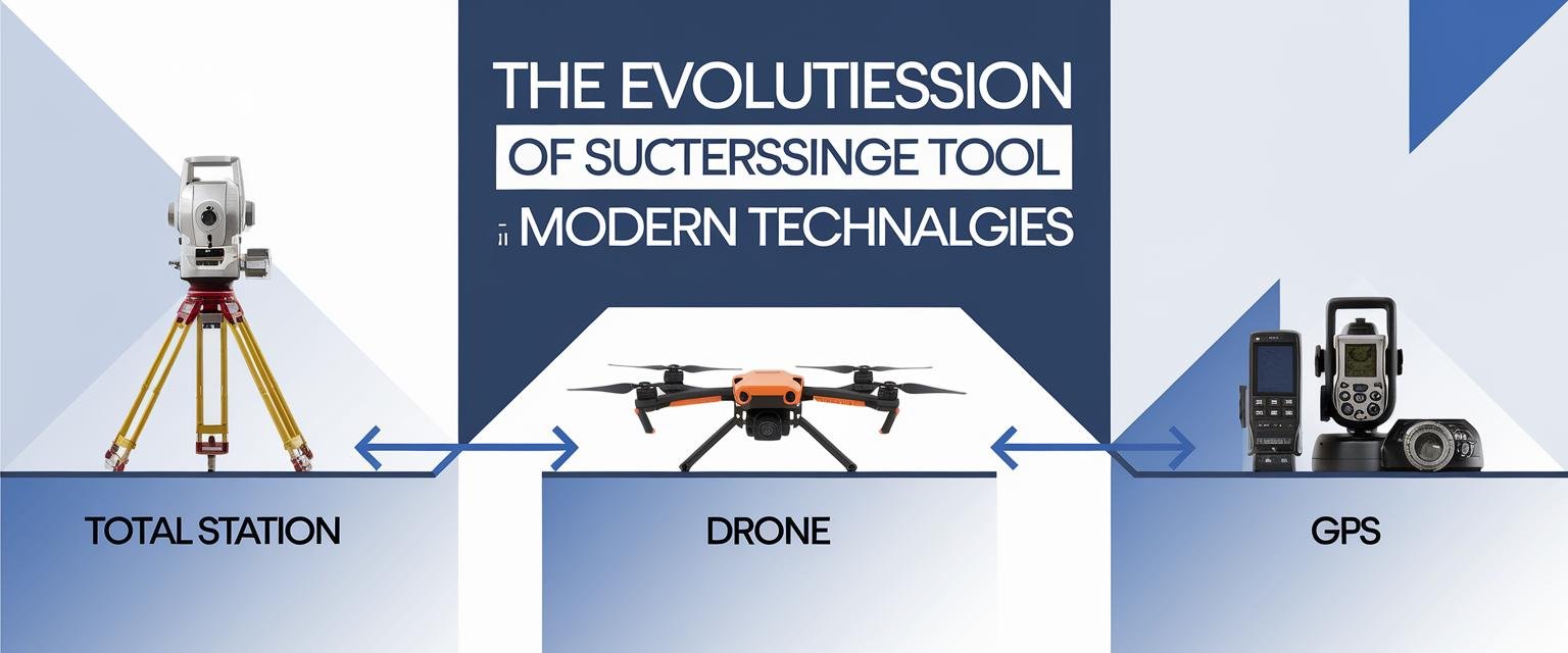
2. Total Stations: The Surveyor’s Workhorse
If there’s one tool that revolutionized surveying in recent decades, it’s the total station. This device combines an electronic theodolite (for measuring angles) with an electronic distance meter (EDM) to measure both horizontal and vertical angles and the slope distance from the instrument to a point.
Modern total stations offer:
- Accuracy to within millimeters
- Built-in data storage
- Wireless connectivity
- Reflectorless measurement capability
- Robotic operation (reducing field crew size)
The total station has emerged as the standard workhorse for most surveying applications, from boundary surveys to construction layout. During my work on a commercial building project, we used a total station to lay out column positions with precision that would have been impossible with older equipment.
What makes total stations particularly valuable is their versatility. They can be used for:
- Topographic surveys
- As-built documentation
- Building layout
- Road alignment
- Volume calculations
Most modern total stations also feature onboard computers that can perform calculations and store data in the field, drastically reducing the potential for human error in recording measurements.
3. Global Positioning System (GPS) Receivers
GPS technology has transformed surveying by allowing positions to be determined anywhere on earth without requiring line-of-sight observations between points.
Survey-grade GPS receivers are far more precise than the navigation GPS in your phone. They can provide centimeter-level accuracy through techniques like:
- Real-Time Kinematic (RTK) GPS – Uses a base station and rover to achieve centimeter accuracy in real-time
- Static GPS – Involves longer observation periods for greater accuracy
- Network RTK – Utilizes a network of permanent base stations for corrections
GPS is particularly valuable for:
- Establishing control networks
- Surveying large areas quickly
- Working in areas with limited access
- Monitoring ground movement
I recall using RTK GPS to survey a 5-mile corridor for a utility project. What would have taken weeks with conventional methods was completed in just days. However, GPS does have limitations – it requires clear sky view and doesn’t work well under heavy tree canopy or near tall buildings.
4. 3D Laser Scanners
One of the most impressive advances in surveying technology is the 3D laser scanner, which captures millions of points in minutes to create detailed 3D models of structures and landscapes.
These scanners work by emitting laser beams that bounce off objects and return to the scanner. By measuring the time it takes for the laser to return, the scanner calculates the distance to each point. The result is a “point cloud” – essentially a digital 3D snapshot composed of millions of individual measurements, much like how a digital photo is made up of millions of pixels, but in three dimensions rather than two.
Applications for 3D laser scanning include:
- Creating as-built documentation of existing structures
- Heritage preservation and documentation
- Complex industrial plant surveys
- Tunnel and bridge inspections
- Crime scene investigation
The technology shines in complex environments where traditional surveying would be challenging or dangerous. As a practical example, I witnessed a 3D scanner document an entire historic building interior in less than a day – a task that would have taken weeks using traditional methods.
5. Unmanned Aerial Vehicles (Drones)
Drones have transformed surveying by providing affordable aerial perspectives that were once only possible with expensive aircraft surveys.
Modern survey drones are equipped with:
- High-resolution cameras for photogrammetry
- LiDAR sensors for creating detailed terrain models
- RTK GPS for precise positioning
- Automated flight planning software
The benefits of drone surveying include:
- Rapid data collection
- Access to dangerous or difficult areas
- Regular monitoring of construction progress
- Creating orthomosaic maps and 3D models
On a recent land development project, we used a drone to survey a 200-acre site in just a couple of hours – a job that would have taken a field crew at least a week using traditional methods. The drone captured thousands of overlapping photos that were processed into a detailed topographic map and 3D model.
While drones offer incredible advantages, they do have limitations including battery life, weather sensitivity, and regulatory restrictions. However, for many applications, they represent the future of efficient surveying.
6. Mobile LiDAR Systems
Mobile LiDAR systems mount laser scanners on vehicles to rapidly collect 3D data along transportation corridors. These systems combine:
- Multiple laser scanners
- High-precision GPS
- Inertial measurement units
- Cameras for colorizing point clouds
Mobile LiDAR is particularly valuable for:
- Highway inventory and assessment
- Railway corridor mapping
- Urban modeling
- Infrastructure documentation
The key advantage is speed – a mobile LiDAR system can collect data along miles of roadway in a single day, capturing every detail from pavement condition to roadside assets.
I was amazed when I first saw the results of a mobile LiDAR scan of a highway project. The system captured everything – guardrails, signs, pavement markings, drainage structures – with centimeter-level accuracy while traveling at highway speeds.
7. Ground Penetrating Radar (GPR)
Not all surveying happens above ground. Ground Penetrating Radar (GPR) allows surveyors to “see” what’s beneath the surface without excavation.
GPR works by sending radio waves into the ground and recording the reflections that occur when those waves encounter different materials. This creates profiles showing:
- Underground utilities
- Voids and sinkholes
- Buried structures
- Soil layers
- Groundwater tables
GPR has become essential for urban construction where underground utilities pose significant risks. According to the American Society of Civil Engineers, utility strikes during construction cost billions annually in damages, delays, and occasionally lives.
On an urban redevelopment project, we used GPR to locate a forgotten century-old water main that wasn’t on any utility maps. This discovery allowed us to reroute foundation elements, avoiding a potential disaster during excavation.
8. Bathymetric Surveying Equipment
For projects involving water bodies, bathymetric surveying equipment measures underwater depths and features. This specialized equipment includes:
- Single-beam echo sounders
- Multi-beam systems for complete coverage
- Side-scan sonar for detailed seafloor imaging
- Sub-bottom profilers for sediment layers
Applications include:
- Harbor and channel dredging
- Bridge foundation design
- Offshore construction
- Environmental monitoring
- Flood modeling
When working on a coastal protection project, bathymetric surveys were essential for understanding the underwater topography and designing effective structures. The combination of land and underwater survey data created a complete picture of the project area.
9. Survey-Grade Digital Cameras
Digital photogrammetry has been transformed by survey-grade cameras specifically designed to capture images for measurement purposes. These cameras feature:
- Calibrated lenses with minimal distortion
- High-resolution sensors
- Precise positioning data
- Specialized processing software
The applications include:
- Aerial mapping (when mounted on aircraft or drones)
- Facade documentation
- Volume measurements
- Site monitoring
I’ve seen remarkably detailed 3D models created purely from photographs, accurate enough for construction documentation. On historical preservation projects, these cameras allow documentation of intricate details that would be nearly impossible to survey with other methods.
10. Surveying Software
Perhaps the most transformative tool isn’t hardware at all, but the sophisticated software that processes and analyzes survey data. Modern surveying software includes:
- CAD programs like AutoCAD Civil 3D
- Specialized packages like Trimble Business Center
- GIS software like ArcGIS
- Point cloud processing tools like CloudCompare
- Photogrammetry software like Pix4D
What makes today’s software revolutionary is its ability to integrate data from multiple sources – GPS, total stations, laser scans, and photos – into unified 3D models that represent reality with unprecedented accuracy.
Today’s surveyors spend as much time processing data as collecting it, and mastering the right software is essential for career success. If you’re looking to build skills for your resume, learning one of these key programs is a great investment. Our resume builder tool can help you highlight these technical skills effectively.
How Surveying Tools Complement Each Other
What’s fascinating about modern surveying is how these various tools complement each other, forming a comprehensive toolkit where each technology compensates for the limitations of others:
Integrated Workflows
A typical modern surveying project might combine multiple tools in this way:
- Initial reconnaissance – Drone survey to capture overall site conditions
- Control establishment – GPS to set precise reference points
- Detailed topography – Total station or laser scanner for critical areas
- Underground investigation – GPR to locate utilities
- Verification – Traditional levels for final elevation checks
During a complex infrastructure project last year, we seamlessly moved between these technologies, choosing the right tool for each specific challenge. The drone provided broad coverage, while the total station gave us pinpoint accuracy for critical structures, and GPR identified potential hazards below ground.
Real-World Applications of Modern Surveying
The tools we’ve discussed don’t operate in isolation – they’re typically used in combination to solve complex engineering challenges. Here are some examples of how these tools come together in real-world applications:
Bridge Construction
For a bridge project I observed, the surveying process included:
- GPS for establishing control points
- Total stations for precise abutment layout
- 3D laser scanning to verify structural elements during construction
- Monitoring systems to track movement during and after construction
The integration of these technologies ensured that bridge segments constructed miles apart would align perfectly during assembly.
Urban Development
In dense urban environments, surveyors often use:
- Mobile LiDAR to capture existing conditions
- GPR to locate underground utilities
- Total stations for precise building layout
- Monitoring systems to ensure construction doesn’t damage adjacent structures
This multi-tool approach helps manage the complexity of building in confined spaces with numerous constraints.
Transportation Infrastructure
For highway and railway projects, typical surveying includes:
- Aerial mapping (drone or aircraft) for corridor planning
- Mobile LiDAR for detailed design
- GPS for construction stakeout
- As-built surveys to verify completed work
The combination provides the comprehensive data needed for these large-scale projects.
Cost and Efficiency Comparisons
The economic benefits of modern surveying tools are substantial. Based on my project experience, here’s how different approaches compare:
| Survey Task | Traditional Method | Modern Method | Time Savings | Cost Savings |
|---|---|---|---|---|
| 100-acre topographic survey | Total station (2-week field work) | Drone survey (4-hour flight) | ~90% | ~60% |
| Building facade documentation | Manual measurements (3 days) | Laser scanner (4 hours) | ~85% | ~70% |
| Highway corridor survey (5 miles) | Total station & level (3 weeks) | Mobile LiDAR (1 day) | ~95% | ~80% |
While the equipment investment for modern methods is higher, the labor savings and increased accuracy typically deliver strong ROI, especially for larger projects.
FAQ: Common Questions About Surveying in Civil Engineering
What are the main types of surveying?
The main types of surveying in civil engineering include:
- Topographic surveying – Maps the natural and man-made features of the land
- Boundary surveying – Establishes property lines and corners
- Construction surveying – Lays out structures according to plans
- As-built surveying – Documents completed construction
- Monitoring surveying – Tracks movement or deformation of structures
- Hydrographic surveying – Maps underwater features
Each type serves different purposes within the construction process.
What tools do surveyors use?
As covered in this article, surveyors use a wide range of tools including:
- Total stations
- GPS receivers
- Levels and leveling rods
- 3D laser scanners
- Drones
- Mobile LiDAR systems
- Ground penetrating radar
- Bathymetric equipment
- Specialized software
The tools chosen depend on the specific requirements of each project.
How accurate is GPS surveying?
GPS accuracy varies depending on the method used:
- Standard single-receiver GPS – Typically 1-5 meters
- Differential GPS – Sub-meter accuracy
- Real-Time Kinematic (RTK) GPS – 1-2 centimeter accuracy
- Static GPS with post-processing – Millimeter accuracy
Factors affecting GPS accuracy include satellite geometry, atmospheric conditions, observation time, and obstruction of the sky view.
What are the advantages of using drones in surveying?
Drones offer numerous advantages including:
- Speed – They can survey large areas much faster than ground methods
- Access – They can safely reach dangerous or inaccessible areas
- Cost-effectiveness – They’re less expensive than traditional aerial surveys
- Frequency – They allow for regular monitoring of changing conditions
- Comprehensive data – They capture everything visible from above
These advantages make drones particularly valuable for preliminary site assessments and progress monitoring.
What is the future of surveying?
The future of surveying is moving toward:
- Automation – More robotic and autonomous data collection
- Integration – Seamless combination of multiple data sources
- Machine learning – Automated feature extraction and classification
- Augmented reality – Field visualization of design overlaid on reality
- Miniaturization – Smaller, more portable equipment
- Cloud processing – Real-time data processing and sharing
These trends are making surveying faster, more accurate, and more accessible, while reducing the manual labor involved.
Conclusion: The Evolving Landscape of Surveying Technology
Surveying has come a long way from the days of chains and transits. Today’s surveying professionals have an incredible arsenal of tools that combine to create unprecedented accuracy and efficiency.
What impresses me most about modern surveying is how it integrates multiple technologies and data sources to create comprehensive digital representations of reality. These digital twins serve as the foundation for design, construction, and ongoing management of infrastructure.
For students and professionals in civil engineering, understanding these tools isn’t just about technical knowledge—it’s about seeing the possibilities they create for solving complex problems. Each advancement in surveying technology opens new doors for what we can build and how we can build it.
If you’re planning a career in civil engineering or surveying, investing time in learning these technologies will give you a significant advantage. The field continues to evolve rapidly, with automation and artificial intelligence beginning to transform workflows even further.
Want to prepare for interviews in this field? Check out our comprehensive collection of interview questions to help you showcase your knowledge of surveying tools and techniques.
Remember that regardless of how advanced the technology becomes, the fundamental principles of measurement and spatial relationships remain the same. The best surveyors combine technological proficiency with a deep understanding of these principles to deliver results that truly make a difference in the built environment.